Shipping in the Oil and Gas industry requires monitoring of company marine vessel paths and worldwide travel, especially for offshore extraction activities management, security and as part of their distribution strategy. A reliable detection of all sailing or stationary vessels is necessary to tackle manipulated or 'dark vessels' that have turned off identification systems (e.g. Automatic Identification System (AIS), Long Range Identification and Tracking (LRIT)) and anomalous behaviours. Dangerous behaviours, such as those from company ships or unknown vessels, need to be identified and proven to inform decision-making (pollution activities such as illegal bilge dumping, suspected pirate attacks, unofficial routes, etc.).
Telespazio UK utilises e-GEOS-powered technology to deliver a high frequency Synthetic Aperture Radar (SAR) data monitoring campaign to support defence and marine forces in Maritime Situational Awareness services, coast guards, international marine environmental defence and protection organisations.
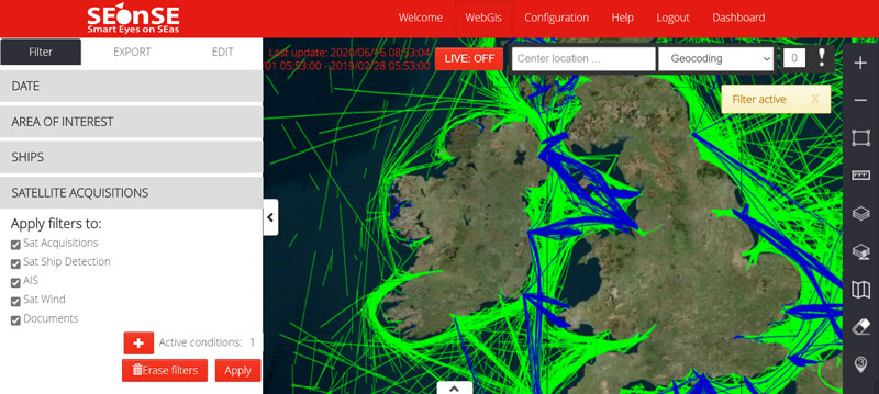
Developed by e-GEOS, Telespazio UK utilises a fully integrated processing platform, Smart Eyes on the Seas (SEonSE) to facilitate the continual observation of targets at sea across large areas.
Near real-time reports of Maritime Situation Awareness are produced based on the positioning and forecasted vessel route according to the customer alert workflow. This provides:
- Near real-time vessel detection and tracking maps
- Wind and wave analysis
- Ice charting
- Geospatial analysis and alert notifications
- Oil-spill detection
- On-off shore platform / infrastructure subsidence
- Oil seepage detection
Managing the UK’s coastal and offshore waters and ports with maritime vessel detection and behavioural analysis
Illegal, unreported and unregulated (IUU) fishing is itself a complex subject. Within the maritime environment, there are various systems designed to allow a vessel to make known its location, destination and other parameters. Monitoring of IUU fishing requires a variety of data sources to detect vessels in protected and licensed areas, account for cooperative vessels and hone in on uncooperative vessels.
Traditional Automatic Identification System (AIS), marine coastal radar, vessel or shoreline reporting, and aerial imaging alone are insufficient and ineffective in managing vast areas of ocean. Correlating satellite imaging and satellite AIS, and further combining the resultant detections with behavioural analysis, fills the gap left by patrols and ground-based systems. This disrupts uncooperative behaviours of the vessels’ owners and provides evidence for prosecutions where the behaviours of uncooperative vessels persist.
In this application domain, Telespazio UK and e-GEOS have considerable combined experience and their proprietary technology provides a well-trodden and robust modular Maritime Surveillance Platform – SEonSE.
SEonSE supports the detection of vessels with failed or malfunctioning GPS and/or transmitting equipment; vessels that deliberately deactivate their AIS to avoid detection; vessels that, because of their smaller size, are not under the obligation of having an on-board positioning system; as well as sport fishing vessels.
The platform also identifies abnormal behaviours, such as trawlers in forbidden areas; vessels in environmental protected zones; ships stationary in unusual locations; and ships sharing an unusually proximal location to one another.
Furthermore, SEonSE can identify oil spills and their characteristics; relevant met-ocean information; and correlate these to obtain with high confidence the vessel and/or platform polluters.
The operational use of satellite-derived analytics for maritime applications allows worldwide ocean and sea monitoring, irrespective of whether the area is within the range of coastal surveillance systems; the behaviour of ships is cooperative or uncooperative; and the time of day.
Where detections and behavioural analysis is required in near real-time, it is possible to utilise ground-station antenna to receive, downlink and process satellite imagery at local processing environments in the form of a COSMO-SkyMed Customer User Terminal (CUT). The CUT provides reception of COSMO-SkyMed imagery directly from satellite constellation and the central archives located in Matera.
When operated within a CUT environment, SEonSE detections and behavioural analysis may provide rapidly distributed notifications, with specific situational awareness calls-to-action, to multiple stakeholders. This near real-time processing environment facilitates a greater number of interceptions and prosecutions, acting as a potent discouraging measure.
An example of the SEonSE platform is demonstrated below.


